What would we learn about Singapore’s architectural and urban history if we focused on just one group (or two closely related groups, if you like), the Makassarese and Bugis?
First, who are the Makassarese and the Bugis? A detailed book-length discussion may be found in the book The Bugis by the late Christian Pelras (1996). But briefly, the Makassarese (Tu Mangkasara’) come from the southernmost districts of South Sulawesi province, in what is today eastern Indonesia, around the historical post city of Makassar. The Bugis (sometimes ‘Buginese’, endonym: To Ugi’), on the other hand, consists of a number of groups, prominent among whom are the Wajo’ and Boné, who live to the north of the Makassarese, still in South Sulawesi province. Their languages are very closely related. Beyond their home province of South Sulawesi, both Makassarese and Bugis are often glosssed /grouped together simply as the Bugis.
When we turn to the early history of Singapore Town, it will be apparent that the Bugis (and Makassarese) were once accorded a prominent place in the scheme of things.
Bugis and Makassarese individuals built, bought and owned property in various parts of the old city.
Arguably, however, the most important part of town for the Bugis and Makassarese community is the demolished neighbourhood of Kampung Rochor, which stood next to Kampung Gelam, shown as the red zone in the foreground in the aerial photograph of the Beach Road – Kampung Gelam area below.
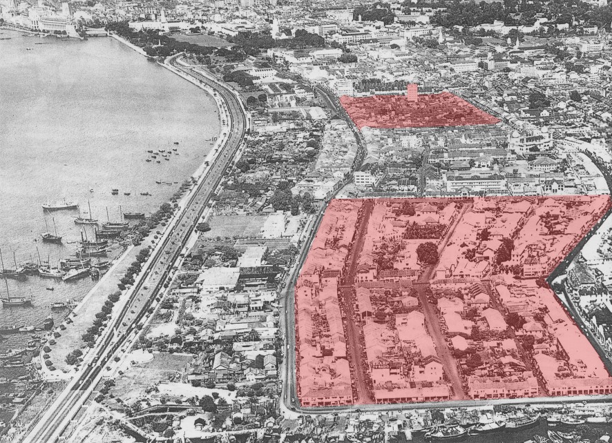
Aerial photograph, 1964. Sultan Mosque and the Istana Kampung Gelam (Malay Heritage Centre today) are visible in the area between the two red plots; to the left is Nicoll Highway. The larger red zone in the foreground was marked as “Bugis Campong” in the Singapore Town Plan of 1822 (by Lieut Philip Jackson). By the 1840s, this neighbourhood, also known as ‘Kampung Rochor, had grown to a network of streets (later called Java Road, Palembang Road, Minto Road, and Sumbawa Road) with the townhouses (shophouses) and residences of Bugis, Malay, and Arab merchants and traders. It was demolished from 1967 to the late 1970s. Hajjah Fatimah Mosque is the only feature still standing there today. Hajjah Fatimah is a Melaka mechant of Bugis descent, and her husband was a prince (Karaeng) from the Makassarese royal house of Gowa (part of the Gowa-Tallo’ alliance that ruled the port of Makassar in the 1500s to the 1600s). The red zone in the background are the streets beyond Haji Lane and Bali Lane that were demolished in 1995.
The name “Bugis Town” appears on maps of Singapore from 1822 (attributed to Capt James Franklin, below) and another map of 1825 (map below), where it is larger in extent than even the generous area allotted for the Bugis trading community and labelled “Bugis Campong” in the so-called “Jackson Plan” (map below), Singapore’s town plan drawn up by Lieut Jackson by Dec 1822 (and not to be confused with Kampung Bugis at Kallang).

1822 Map of Singapore (detail), attributed to Capt. James Franklin, showing Bugis Town (around the site of Raffles Hospital to Bugis Junction and the National Library today), a Chinese Town just south of Boat Quay, and a Malay Town to its south, around Telok Ayer Street.
The old “Bugis Town” of early nineteenth-century Singapore indicated in this 1822 map seems to have persisted in its original location for a few years longer despite Raffles’ directives of Oct 1822 to remove the Bugis from the area around what is today Bugis Junction.
The site of the relocation is shown prominently in this 1825 map, again as “Bugis Town” (below).

1825 map of Singapore showing Bugis Town around the Istana and Sultan Mosque (Kampung Gelam Palace and town). The name “Campong* Glam” is indicated where Bugis Town was written in the 1822 map (above).
*note: “Campong” is the Anglicised spelling for “Kampung” with which the term entered the English dictionary / language.
Bugis and Makassarese merchants and traders in Singapore also lived and owned properties all across Singapore Town — including in the areas we label “Chinatown” today.

Site of Bugis Town in 1822 map by Capt James Franklin, and the new site of “Bugis Campong” in Jackson Plan 1822 and indicated as “Bugis Town” in a map from 1825 (see above).
Annotation by Imran bin Tajudeen.
In this talk we review a slice of nineteenth-century Singapore urban social history by focusing on the Bugis and Makassarese–two mercantile groups from South Sulawesi, eastern Indonesia–as seen from old maps indicating the neighbourhoods of as well as pictorial evidence on the traditional houses, shophouses, and other buildings that were constructed by the community. We will look at both examples that have been lost through demolitions as well as surviving buildings still standing in our midst–including philanthropic endowments called waqf (wakaf).

Rumah Gudang (Warehouse-Dwelling) built for a Bugis merchant Daying (Daeng) Desarwa, by architects Kassim & Siang Hock, 1893 (since demolished) at Jalan Klapa, Kampung Gelam, Singapore.
Among the Bugis merchants who lived in Kampung Gelam town was Haji Osman @Daeng Passendrik Ambo’ Dalle’ bin Haji Ali (see article by Daeng Paliweng here). His grave is in the old cemetery of the port town at Jalan Kubor / Victoria Street (image below).
![Beneath the domed pavilion lies the grave of the Bugis merchant Haji Osman Daeng Passendrik [Pasandrik] Ambo' Dalle' (Ambok Dalek) bin Haji Ali, in Jalan Kubor Cemetery, Kampung Gelam, Singapore. Photograph by Imran bin Tajudeen, 2013](http://singapurastories.com/wp-content/uploads/2015/08/Daeng-Passendrik-Hj-Osman-Hj-Md-Said-b-Daeng-Patompok-768x1024.jpg)
Beneath the domed pavilion lies the grave of the Bugis merchant Haji Osman Daeng Passendrik [Pasandrik] Ambo’ Dalle’ (Ambok Dalek) bin Haji Ali, in Jalan Kubor Cemetery, Kampung Gelam, Singapore. Photograph by Imran bin Tajudeen, 2013.

A shophouse unit owned by Hj Daeng Pasandrek Ambok Dalek at no.32, Arab Street, drawings for a 1905 rebuilding plan following a fire.
These are among the interesting. forgotten aspects of Bugis and Makassarese histories in Singapore town that will be discussed in the talk.
Do join us on Saturday 28 Oct, 230pm at MHC Auditorium!
This page contains a sampling of information that will be shared for a Public Lecture held in conjunction with Sirri na Pesse: Navigating Bugis Identities in Singapore, special exhibition in the Malay Cultural Festival 2017, Malay Heritage Centre, Singapore.
Saturday 28 October 2017
2:30 PM – 4:30 PM, MHC Auditorium
Malay Heritage Centre (Istana Kampung Gelam), Singapore

Leave a Reply